Expertises
SERVICES
Relevé Topographique
Relevé Bathymétrique
Relevé de Bâtiment
Inspection Technique
Audiovisuel
SECTEURS
Energies Renouvelables
Collectivité
Industrie
BTP
TECHNIQUES
Photogrammétrie
Lasergrammétrie
Lidar
Bathymétrie
MATERIELS
Aérien
Terrestre
Aquatique
Sur mesure
Réalisations
Entreprise
Notre entreprise
Notre actualité
Contact
03 61 08 02 24
03 61 08 02 24
Archives
Home
CARTOGRAPHIE SIG
+
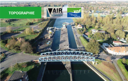
5 ans de collaboration avec les VNF
1 décembre 2022
|
CARTOGRAPHIE SIG
,
ÉTUDE TOPOGRAPHIQUE
,
INSPECTION D'OUVRAGE
,
INSPECTION TECHNIQUE
,
NUAGE DE POINTS (RELEVÉ BATHYMÉTRIQUE)
,
ORTHOPHOTO HAUTE-RÉSOLUTION
,
ORTHOPHOTOPLAN
,
PHOTOGRAMÉTRIE
,
Réalisation
,
RELEVÉ TOPOGRAPHIQUE ET CARTOGRAPHIQUE
|
10 Min Read
5 ans de collaboration avec les VNF Marché à bon de commande : auscultation et diagnostique des ouvrages de navigation de la direction territoriale Nord-Pas-de-Calais des Voies Navigables de France Détails du [...]
Read More
by
Air Scanner